
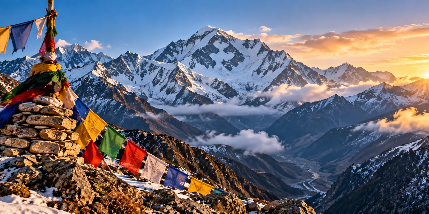
Om Parvat is a sacred Himalayan peak rising to 6,191 meters (20,312 feet) in the Pithoragarh district of Uttarakhand. It is famous for a natural snow formation on its dark mountain face that resembles the Hindu symbol ॐ (Om). The striking formation can be viewed from the Nabhidhang area in the high Himalayas.
Reaching Om Parvat is not a simple sightseeing trip. The journey takes you from Dharchula into the remote Vyas Valley through places such as Gunji and Kalapani. High altitude, changing weather, permits and border-area restrictions make proper planning important.
This guide covers Om Parvat’s location, yatra route, best time to visit, permits, how to reach, nearby places, accommodation, things to carry and important safety tips for planning your trip.
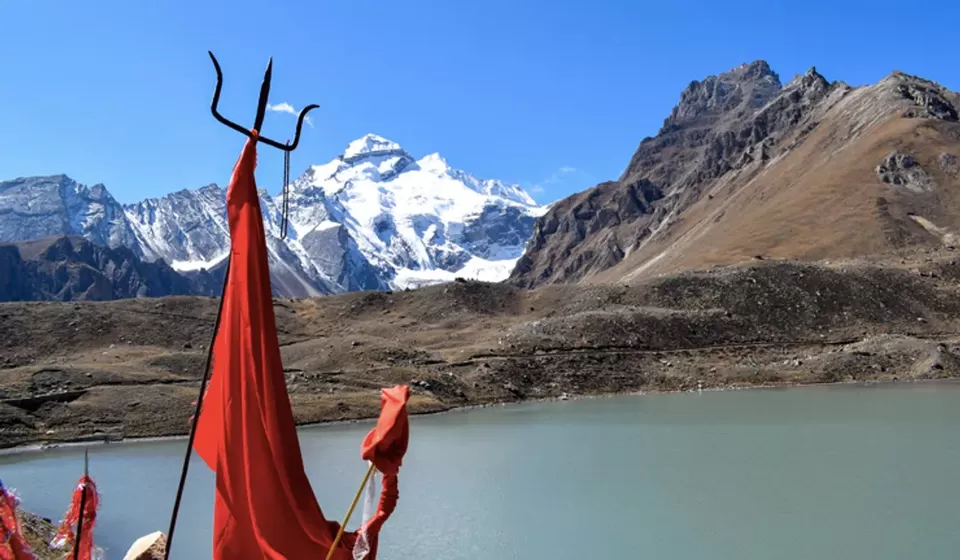
Om Parvat Information
| Information | Details |
| Location | Pithoragarh district, Uttarakhand |
| Region | Vyas Valley |
| Main base | Dharchula |
| Main viewpoint | Nabhidhang |
| Famous for | Natural ॐ-shaped snow formation |
| Viewpoint altitude | Around 4,200–4,300 m |
| Nearby places | Gunji, Kalapani, Adi Kailash, Parvati Kund |
| Travel type | Mountain road journey with short walks |
| Main travel season | Generally May–June and September–October |
Where Is Om Parvat?
Om Parvat is located in the Vyas Valley of Pithoragarh district in Uttarakhand, close to the India-Nepal-Tibet border region.
For most travelers, Dharchula is the starting point for the journey. From Dharchula, the route moves deeper into the mountains through places such as Gunji and Kalapani before reaching Nabhidhang, where the famous Om-shaped formation can be viewed.
The area is remote and sits at a much higher altitude than towns such as Dharchula. Because of its location near the international border, travel is also subject to permissions and local security arrangements.
Om Parvat is part of the same wider Himalayan pilgrimage region as Adi Kailash, which is why many travelers plan both destinations together.
Things to Do at Om Parvat
1. See the Natural ॐ Formation
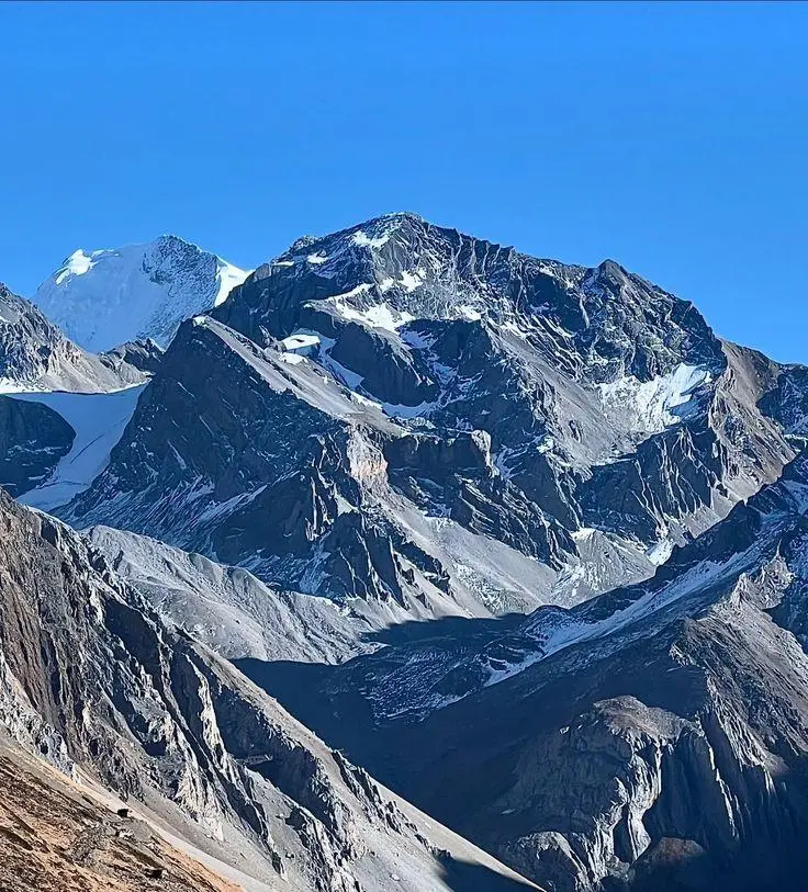
The main reason people travel to Om Parvat is to see the natural ॐ-shaped formation on the mountain.
From the designated viewing area near Nabhidhang, the formation can be seen when the weather is clear. The contrast between the white snow and dark mountain rock makes the shape particularly striking.
Do not expect the formation to look equally clear every time. Clouds can move across the mountain quickly, and changes in snow and sunlight can affect its appearance.
2. Visit Nabhidhang
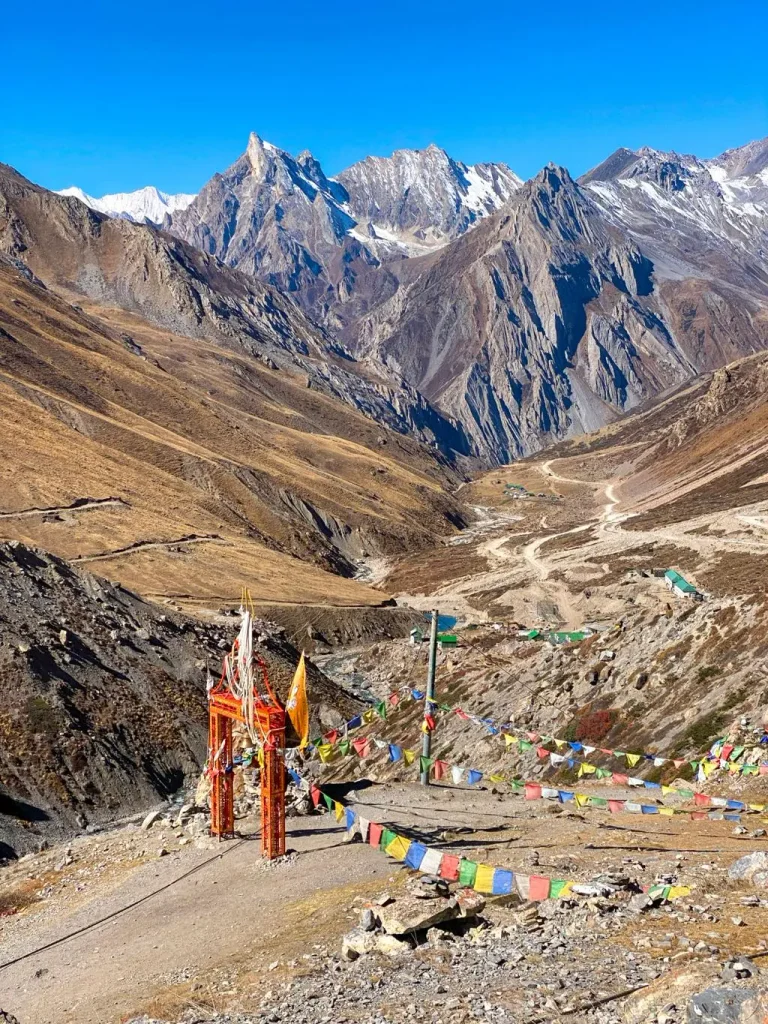
Nabhidhang is the main viewpoint associated with Om Parvat. It is located at a high altitude, so the short distance around the viewpoint can still feel physically demanding.
Take your time, avoid unnecessary walking and follow the instructions given by local authorities or your travel group.
3. Travel Through the Vyas Valley
The road journey through the Vyas Valley is one of the memorable parts of the yatra. The scenery becomes increasingly remote as you move towards the higher areas.
Gunji and Kalapani are important stops along the route, while the final stretch towards Nabhidhang takes you into a much colder and more rugged landscape.
4. Visit Other Sacred Places
If your itinerary and current access conditions allow, Om Parvat can be combined with other important places in the region, particularly Adi Kailash and Parvati Kund.
Because these destinations are in a remote border region, do not try to fit too many places into a tight schedule. Road conditions and weather can easily change your travel plans.
Om Parvat Route
The Om Parvat route generally follows this broad journey:
Dharchula → Gunji → Kalapani → Nabhidhang → Om Parvat Viewpoint
A large part of the journey can be covered by road, but the exact amount of walking depends on road conditions, vehicle access and the arrangements in place during your visit.
| Route | Approx. Elevation | Travel |
| Dharchula to Gunji | Around 915 m to 3,200 m | Mainly by mountain vehicle |
| Gunji to Kalapani | Around 3,200 m to 3,600 m | Vehicle/walking depending on conditions |
| Kalapani to Nabhidhang | Around 3,600 m to 4,300 m | Vehicle/walking depending on access |
| Nabhidhang | Around 4,300 m | Short walk to viewing area |
These elevations and travel arrangements are approximate. Actual road access can change because of weather, landslides, road work, security restrictions and local yatra arrangements.
Dharchula to Gunji
Dharchula is the main base before entering the higher Himalayan region.
From here, the route follows the mountain valleys towards Gunji. The journey involves winding roads and rugged terrain, so travel can take longer than the distance on a map may suggest.
Gunji is also an important place for travelers to rest and adjust to the increasing altitude.
Gunji to Kalapani
From Gunji, the route continues towards Kalapani through the Vyas Valley.
Kalapani is an important stop for both religious and geographical reasons and is associated with the Kali River. Depending on the conditions at the time of your visit, much of this section may be covered by vehicle.
Kalapani to Nabhidhang
The landscape becomes noticeably colder and more barren as you move from Kalapani towards Nabhidhang.
The increase in altitude is the biggest challenge here. Avoid rushing through this section, especially if you are not used to high-altitude travel.
Nabhidhang to Om Parvat Viewpoint
Nabhidhang is the main area from which Om Parvat is viewed.
The final walk may not be very long, but at around 4,300 metres, even a short uphill section can feel difficult. Walk slowly and take breaks whenever needed.
Is Om Parvat a Trek?
Om Parvat is often described as a trek, but that can give the wrong impression.
It is not a traditional trek where you walk the entire route from Dharchula. Improved road connectivity allows vehicles to cover a significant part of the journey. Walking is mainly involved on sections where vehicles cannot go or where local arrangements require it.
The real challenge is the combination of high altitude, long mountain travel, cold weather and remote conditions.
Om Parvat Yatra Difficulty
The Om Parvat journey can be challenging even for people who are comfortable with regular trekking.
The biggest difficulty is not technical climbing. It is the rapid increase in altitude and the conditions of the high Himalayas.
You should be prepared for:
- Altitude above 4,000 metres
- Cold and rapidly changing weather
- Long mountain-road journeys
- Rough road sections
- Limited medical facilities
- Restricted border-area access
- Possible delays because of weather or road conditions
If you are a first-time high-altitude traveler, give yourself enough time to acclimatize and avoid trying to complete the journey in a rushed schedule.
Why Is Om Parvat Famous?
Om Parvat is famous for a naturally occurring snow pattern that looks like the ॐ symbol on the dark rock face of the mountain.
There is no artificial carving or painting involved. Snow collects in the natural grooves of the mountain, creating the distinctive shape. The formation does not look exactly the same throughout the year. Snowfall, melting, sunlight and cloud cover can all affect how clearly the symbol is visible.
This is also why seeing Om Parvat is partly dependent on the weather. You may reach the viewpoint but still have limited visibility if clouds cover the mountain.
Om Parvat Height and Nabhidhang Viewpoint
There is some variation in the elevation figures reported for Om Parvat, with different sources giving different measurements. More importantly for travelers, the mountain itself should not be confused with the viewpoint from where pilgrims see it.
Nabhidhang, the main viewing area, is situated at roughly 4,200 to 4,300 metres above sea level. Visitors do not normally climb to the summit of Om Parvat. The yatra is about reaching the permitted viewing area and having darshan of the natural formation.
At this altitude, even a short walk can feel tiring. The thin air, cold temperatures and changing weather are very different from the conditions at Dharchula.
What Makes the Om Parvat Yatra Special?
The journey to Om Parvat is as much a part of the experience as the destination itself.
After leaving Dharchula, the landscape gradually changes from lower Himalayan valleys to a much colder and more rugged high-altitude environment. The route passes through remote settlements and follows the mountain valleys towards Gunji, Kalapani and Nabhidhang.
You get to see the Kali River, steep mountain slopes, narrow valleys and high Himalayan landscapes along the way. The further you travel, the fewer regular tourist facilities you will find.
For this reason, Om Parvat is better understood as a high-altitude pilgrimage journey, rather than a normal sightseeing trip.
Best Time to Visit Om Parvat
The main travel window is generally May to June and September to October, subject to the official opening of the route, weather and local permissions.
May to June
May and June are among the more popular months for the yatra. Roads are generally more accessible than during the monsoon, while snow can still remain on the mountain.
The nights at Nabhidhang can be extremely cold, so summer does not mean you can travel with normal light clothing.
September to October
September and October can bring clearer mountain views after the monsoon.
The weather can still change quickly, particularly at higher elevations. October also brings colder conditions, so proper winter clothing becomes increasingly important.
July to August: Monsoon
Monsoon is generally not a comfortable period for this journey. Heavy rain can lead to landslides, falling rocks, road damage and travel delays in the mountains.
If you are considering travel during this period, check the latest road and weather situation locally rather than relying on a fixed seasonal schedule.
November to April: Winter
The higher parts of the route experience severe winter conditions, including snowfall and very low temperatures. Access may be restricted or unavailable.
Do not plan a winter visit unless you have confirmed that the route is officially open and that travel is permitted.
When Can You See the Om Formation Clearly?
There is no guaranteed time when the Om formation will be perfectly visible. Its appearance depends on several natural factors, including snow cover, sunlight and cloud conditions. May and June can offer good snow visibility, while September and October can provide clearer post-monsoon skies.
Early morning is often considered a good time for viewing because clouds can build around the higher peaks later in the day.
Still, Himalayan weather can change within minutes. Even with good planning, there is always a chance that clouds may hide the mountain.
Om Parvat Permit and Entry Requirements
Om Parvat is situated in a sensitive border area, so travelers cannot treat the route like an unrestricted tourist road.
You need to follow the current permit and verification requirements before entering the restricted sections. The exact documents and procedure can change, so it is better to confirm the latest requirements in Dharchula before starting the journey.
Depending on the current rules, travelers may be asked for documents such as:
- Government-issued photo ID
- Passport-size photographs
- Medical fitness documents
- Verification documents, if applicable
- Copies of important documents
Keep both originals and photocopies of important documents with you.
Most importantly, do not rely on an old permit checklist found online. Border-area procedures can change, and the requirements applicable during one yatra season may not remain the same in another.
How to Reach Om Parvat
Step 1: Reach Kathgodam or Tanakpur
Kathgodam and Tanakpur are two commonly used railway points for reaching Kumaon.
The better option depends on your starting city and the road itinerary you choose. Pantnagar is the main airport option for the Kumaon region, while flight availability can vary.
Step 2: Travel to Pithoragarh and Dharchula
From Kathgodam or Tanakpur, continue by road towards Pithoragarh and then Dharchula.
Mountain travel takes time, so avoid planning your itinerary based only on the distance. Road conditions, traffic, weather and stops can all affect the journey.
Dharchula is the main base before entering the restricted high-altitude region.
Step 3: Complete the Required Permissions
Before proceeding further, complete the required permit and verification process according to the latest local rules.
Keep your documents accessible because checks may be required at different points.
Step 4: Travel from Dharchula to Gunji
The road from Dharchula to Gunji passes through steep Himalayan terrain and remote settlements.
Suitable mountain vehicles are used for the route, but road conditions can affect both travel time and accessibility.
Step 5: Continue Towards Nabhidhang
From Gunji, the route continues through Kalapani and towards the higher sections of the Vyas Valley.
The final route to Nabhidhang depends on road conditions, permissions and the yatra arrangements operating at that time.
Nabhidhang is the main viewing area for Om Parvat.
Places to Visit Near Om Parvat
Adi Kailash
Adi Kailash is one of the major pilgrimage destinations in the same wider Himalayan region. Also known as Chhota Kailash, it is associated with Lord Shiva and is surrounded by high mountain landscapes. Parvati Kund is another important religious stop commonly included in Adi Kailash itineraries.
Many travelers plan Om Parvat and Adi Kailash together, but the combined journey requires enough time for travel and acclimatization.
Kalapani
Kalapani is an important stop on the route through the Vyas Valley.
The area is associated with the Kali River and has religious significance for pilgrims. The surrounding mountains and valley also make it an interesting stop during the journey.
Kunti Parvat
Kunti Parvat is part of the high-altitude landscape around the pilgrimage route and is associated with local religious traditions connected with Kunti from the Mahabharata.
Visibility depends heavily on weather and cloud conditions, so it may not always be clearly visible during the journey.
Parvati Kund
Parvati Kund is a sacred high-altitude lake associated with Goddess Parvati and forms an important part of the Adi Kailash pilgrimage route.
The lake is surrounded by mountain scenery and is visited as a religious site rather than simply as a tourist attraction. Visitors should respect local customs and avoid disturbing the natural surroundings.
Gunji
Gunji is one of the important settlements on the Om Parvat and Adi Kailash route.
It is commonly used as a resting and acclimatization stop because the altitude increases significantly as the journey continues towards the higher areas.
The village also gives travelers a glimpse of life in this remote Himalayan region.
Where to Stay During the Om Parvat Yatra?
Accommodation becomes simpler as you move away from Dharchula.
Dharchula has the widest choice of hotels and guesthouses, while accommodation farther along the route can include basic guesthouses, homestays, government accommodation and seasonal camps.
Dharchula
Dharchul is the most convenient place to stay before entering the higher-altitude region. You will find more choices for rooms, food and basic services here.
Gunji and Other Remote Stops
Basic accommodation or homestays may be available depending on the season and local arrangements. Facilities are much more limited than in Dharchula.
KMVN Accommodation
KMVN accommodation may be available at selected locations along the pilgrimage route. Availability and operating dates can change, so confirm before travelling.
Seasonal Camps
During the main yatra season, temporary tented camps may operate at some locations. These generally provide basic sleeping arrangements and meals rather than hotel-style facilities.
Do not expect reliable mobile connectivity, ATMs, electricity or shops in every remote section. Carry the essentials with you before leaving Dharchula.
What to Pack for Om Parvat
Packing for Om Parvat requires more attention than packing for a normal hill trip. Even in May or June, temperatures at higher elevations can become very low.
Clothing
- Thermal innerwear
- Fleece or woollen layer
- Warm insulated jacket
- Waterproof and windproof jacket
- Trekking pants
- Woollen socks
- Warm gloves
- Woollen cap
Travel and Trekking Essentials
- Comfortable trekking shoes with good grip
- Trekking pole
- Sunglasses
- Sunscreen
- Headlamp or torch
- Water bottle or insulated flask
- Power bank
- Small backpack
Documents and Cash
Carry your original ID, permits and photocopies of important documents.
It is also sensible to carry enough cash because ATM and digital payment facilities may not be dependable in remote areas.
Food and Personal Items
Pack lightweight snacks such as dry fruits, energy bars and other easy-to-carry food.
Carry your regular medicines, basic first-aid supplies and personal toiletries. Do not depend on finding a pharmacy once you enter the remote sections.
Om Parvat Yatra Safety Tips
The biggest concern during the journey is altitude.
You move from Dharchula at a relatively low elevation to an area above 4,000 metres. Your body needs time to adjust to this change.
Take the journey slowly and use designated stops for rest and acclimatization. Do not try to push through severe symptoms simply because you want to reach the viewpoint quickly.
Possible symptoms of altitude sickness include:
- Headache
- Nausea
- Dizziness
- Unusual tiredness
- Breathlessness
- Confusion
- Difficulty walking
If symptoms become severe or continue to get worse, inform your guide or travel group immediately and move to a lower altitude as advised. Serious altitude-related illness requires medical attention.
A few other precautions are equally important:
- Check the weather before leaving.
- Follow all permit and security instructions.
- Stay on the permitted route.
- Do not attempt to climb Om Parvat.
- Carry sufficient warm clothing.
- Keep emergency contact numbers with you.
- Avoid travelling alone in remote sections.
- Keep extra days in your itinerary for weather and road delays.
- Drink enough water and avoid overexertion.
Is Om Parvat Worth Visiting?
Om Parvat is a destination for travelers who are comfortable with remote mountain journeys and want to experience the spiritual and natural side of the Kumaon Himalayas.
The journey is not particularly convenient. Long road travel, high altitude, basic facilities and changing weather are part of the experience. But for pilgrims and mountain travelers, the combination of the natural ॐ formation, Vyas Valley, sacred sites and remote Himalayan landscape makes the journey very different from a regular Uttarakhand trip.
If you plan to go, focus less on rushing to the viewpoint and more on preparing properly for the altitude, permits, weather and road conditions.
Conclusion
Om Parvat is one of the most distinctive pilgrimage destinations in Uttarakhand, known for the natural snow formation that resembles the sacred ॐ symbol.
The journey takes you from Dharchula into the high Himalayas through places such as Gunji and Kalapani before reaching Nabhidhang, the main viewing area. It is not a conventional trek, as much of the route can be covered by vehicle, but the high altitude and remote conditions make it physically demanding.
Before travelling, confirm the latest permits, road conditions, weather and accommodation arrangements. Give yourself enough time to acclimatize, carry suitable clothing and follow local instructions throughout the journey.
For a trip to a remote border-region destination like Om Parvat, good preparation matters just as much as the destination itself.
Frequently Asked Questions
Om Parvat gets its name from the natural snow formation on its dark mountain face, which resembles the sacred ॐ symbol. The pattern is formed naturally by snow collecting in the mountain’s grooves.
It depends on the current access rules and permit requirements. Since Om Parvat is located in a sensitive border region, travelers must follow the permissions and travel conditions applicable at the time of their visit.
The number of days depends on your starting point, road conditions, acclimatization requirements and whether you also plan to visit Adi Kailash. A combined trip generally needs several days rather than a quick weekend itinerary.
First-time high-altitude travelers can visit with proper preparation, but the journey should not be treated as an easy trek. Altitude, cold weather, long road journeys and limited facilities make preparation important.
Yes. Both destinations are located in the same wider pilgrimage region and are commonly included in combined yatra itineraries. However, the exact route and access arrangements can vary by season.
May to June and September to October are generally considered suitable travel periods, but visibility depends on snow, sunlight and cloud cover. Early morning can offer better viewing conditions, although clear visibility cannot be guaranteed.
The Nabhidhang viewing area is around 4,200 to 4,300 metres above sea level. This is the area from which visitors view Om Parvat; it should not be confused with the elevation of the mountain itself.
It can be visited with proper planning and by following the applicable local rules. The main concerns are high altitude, rapidly changing weather, remote roads and limited medical facilities. Visitors should follow local instructions and avoid travelling beyond permitted areas.

2 thoughts on “Om Parvat: Location, Yatra, Route & Complete Travel Guide”